

LiDAR, which stands for Light Detection and Ranging, is a technology pervading many different industries. One of the biggest examples is driverless cars. LiDAR can help a vehicle understand and respond to the changing environment around it. An increasing number of car manufacturers are introducing LiDAR-based systems, such as Volvo’s EX90 fully electric SUV, to help keep the vehicle a safe distance from other traffic and obstacles in the road ahead.
But it isn’t just on the ground where LiDAR technology is being used. Today, LiDAR is widely used for topographic mapping to create detailed three-dimensional representations of overland terrain, as well as Bathymetric surveys that study the depth of large bodies of water. The technology has even been used on spacecraft to monitor the Earth and to help Apollo 13 astronauts return safely.
Given that LiDAR technology has been around since the 1960s, why have so many experts named it as one to watch and ‘the next big thing’ in 2025?
Let’s take the security industry as another example. ABI Research forecasts the worldwide market for smart LiDAR sensors in the sector will surpass three million total installations in the next five years. LiDAR enables virtual perimeter ‘fences’ or ‘safe zones’ to detect and track unauthorised movement with pinpoint accuracy. This is undoubtedly a game-changing application; however, it is the ability to create digital twins using LiDAR that is causing a major paradigm shift.
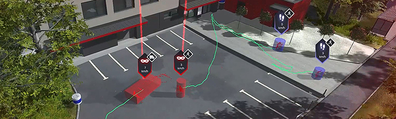
In simple terms, a digital twin is a virtual model, or clone, of something that exists physically. However, it is far more intelligent than a digital representation or map. Using modern 3D LiDAR systems, a digital twin can quickly run complex simulations to assess the likely impact of an almost limitless range of scenarios in the real world.
Digital simulations based on highly accurate 3D LiDAR models can be used by shopping complexes, factories and warehouses, airports, critical infrastructure sites and even a whole town or city to understand how an incident or activity would play out in the real world. The applications are vast, and you don’t need to be a NASA scientist or have a space race budget to use it.
Today, the digital and real worlds are becoming increasingly interconnected. We create, inhabit and share virtual environments from Minecraft to the Metaverse. The latest advances in 3D LiDAR systems enable us to place the real world in the digital world, and in doing so can help to make our physical spaces safer, more secure, run with greater efficiency and capable of responding as environments and the demands placed upon them change.
Author: Martin Vojtek, Business Director 3D Surveillance at Hexagon